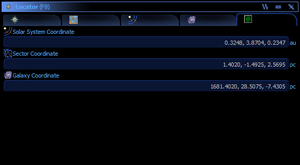
Locator: Difference between revisions
(Basic page.) |
(Added category.) |
||
| (7 intermediate revisions by the same user not shown) | |||
| Line 1: | Line 1: | ||
The '''Locator''' window contains all maps and location data. | The '''Locator''' window contains all maps and location data. | ||
Each of the tabs can be opened as a separate window if so desired. | |||
==Compass== | |||
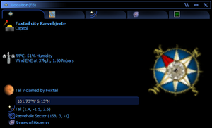
The compass tab contains compass, coordinates and some information about the current environment. | |||
[[File:LocatorCompass.png|thumb|none|The Compass tab of the Locator window. Standing at the [[capitol]] building in a [[city]].]] | |||
==World Map== | |||
The world map shows the surface of the current [[world]], along with location and coordinate information. The sunlight emulation can be turned on and off via the right-click context menu. | |||
On the right is a list of place of interest. | |||
[[File:LocatorWorldMap.png|thumb|none|World map showing the surface with a [[city]] during the day.]] | |||
The colors on the world map are dependent on the [[building]] type: | |||
* [[Military_Headquarters|Military headquarters]] is always red | |||
* Other [[Military_Building|military building]]s are orange | |||
* [[Capitol]] is blue | |||
* [[Airport_Terminal|Airport terminal]] is green | |||
* All over civilian buildings are yellow | |||
* [[Claim]] flag is purple | |||
* [[Road]]s are black | |||
==System Map== | |||
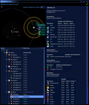
The system map is a map of the current [[Solar_System|solar system]]. If the system has been surveyed it will also contain the [[System_Survey|system survey]] details. | |||
[[File:LocatorSystemMap.png|thumb|none|System map with [[System_Survey|system survey]] details.]] | |||
==Star Map== | ==Star Map== | ||
| Line 6: | Line 34: | ||
The star map shows all explored [[Solar_System|solar system]]s and unexplored solar systems in surrounding [[sector]]s. | The star map shows all explored [[Solar_System|solar system]]s and unexplored solar systems in surrounding [[sector]]s. | ||
The star map shows location of all [[cities]] and [[base]]s belonging to the empire. Any discovered non-empire cities and bases within 17.32[[Parsec|pc]] of an empire [[Airport_Terminal|airport terminal | The star map shows location of all [[cities]] and [[base]]s belonging to the empire. Any discovered non-empire cities and bases within 17.32[[Parsec|pc]] of an empire city with an [[Airport_Terminal|airport terminal]] will also be shown.[http://hazeron.com/mybb/showthread.php?tid=791] | ||
It is possible to display the [[System_Survey|system survey]] report of any system that has been surveyed. | It is possible to display the [[System_Survey|system survey]] report of any system that has been surveyed. | ||
[[File:LocatorStarMap.png|thumb|none|Star map showing a selected [[sector]] and [[Solar_System|solar system]].]] | |||
==GPS== | ==GPS== | ||
The GPS tab contains all the relative coordinates. | The GPS tab contains all the relative coordinates. | ||
[[File:LocatorGps.png|thumb|none|The GPS tab of the Locator window.]] | |||
[[Category:Guides]] | [[Category:Guides]] | ||
[[Category:User_Interfaces]] | |||
Latest revision as of 11:26, 24 February 2024
The Locator window contains all maps and location data.
Each of the tabs can be opened as a separate window if so desired.
Compass
The compass tab contains compass, coordinates and some information about the current environment.
World Map
The world map shows the surface of the current world, along with location and coordinate information. The sunlight emulation can be turned on and off via the right-click context menu.
On the right is a list of place of interest.
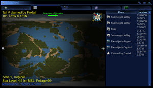
The colors on the world map are dependent on the building type:
- Military headquarters is always red
- Other military buildings are orange
- Capitol is blue
- Airport terminal is green
- All over civilian buildings are yellow
- Claim flag is purple
- Roads are black
System Map
The system map is a map of the current solar system. If the system has been surveyed it will also contain the system survey details.
Star Map
The star map is bond to the empire, each empire have their own star map, and star map information cannot be transferred or shared with other empires.
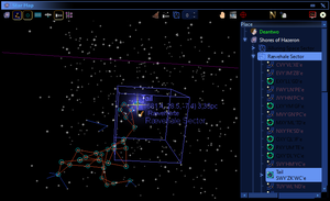
The star map shows all explored solar systems and unexplored solar systems in surrounding sectors.
The star map shows location of all cities and bases belonging to the empire. Any discovered non-empire cities and bases within 17.32pc of an empire city with an airport terminal will also be shown.[1]
It is possible to display the system survey report of any system that has been surveyed.
GPS
The GPS tab contains all the relative coordinates.
